Saturday, October 28, 2006

Again, a diversion from climbing, but for something too many people need to think about more than they do. No, the Pat in this isn't me--thankfully.

http://www.truthdig.com/report/item/200601019_after_pats_birthday/

Tuesday, October 24, 2006

Stove Mountain

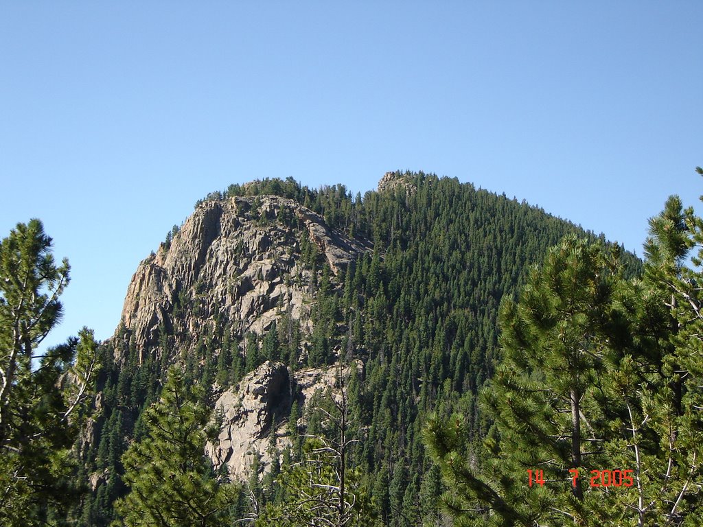
23 October, 2006: I’ve taken the trail that goes up past St. Marys Falls more than a dozen times, en route to Mt. Rosa to the west. Each time, the trail has brought me to within a half mile or so (as the crow flies) of the summit of Stove Mountain. You get a good view of the cliff face on the east side of Stove from the trail, and I’ve always told myself that, one of these times, I would either make it a destination in and of itself, or make a slight detour on one of my Rosa climbs, and finally bag this summit.

I knew it wasn’t likely to be a difficult summit, despite the impressive look of the east face. The western side is a gentle, forested slope leading to the abrupt drop-off at the top. It’s not even very high: The topo figure is 9,781 ft. Given that virtually all Colorado mountains have “gained” 5 to 8 feet as a result of satellite re-measurements, I figure 9,785 is probably a fairly accurate figure—well below timberline. Still, it’s a named summit, and I had never climbed it.

So, since Suzi’s return from her art trip to New York had made it unfeasible for me to do my usual Sunday run, and, better still, since the forecast for Monday was for sunshine all day long, I decided that the time had come to give Stove Mountain a try at last. I left the Gold Camp Road parking lot trailhead at exactly 10 am MDT.

I wasn’t sure how long this run/climb would take me, because there’s some bushwhacking involves once one leaves the trail, just above the falls. I had actually found a couple of trip reports online which mentioned indistinct sections of trail, and the topo map actually shows a trail part of the way up the west side of the mountain. But my sense was that quite a lot of the route would involve dead-reckoning plowing through the trees. I was right.

Just under an hour and a half sufficed to get me above the fall, to where I had noticed a trail spur leading south, down into the creek drainage which feeds St. Marys Falls. The drop of just a few dozen feet to the creek revealed no sign of a trail any farther. This may have been because, in late October, the north-facing slope on the other side (and in the bottom) was already covered with a few inches of snow. Thus, I simply started slogging through the snow, heading up and generally south-southeast, aiming for the saddle I had seen from the trail, west of my target summit.

The snow was not deep. Thankfully. I might have been a bit more comfortable if I had been diligent to bring gaiters—my socks did eventually get soaked—and it would have been truly uncomfortable if the temperature had been low enough. But it was a sunny, warm day, and not a cold, windy one, so I was okay. Besides, I was trying to travel light, carrying only a small belt pack, so I didn’t really have room to carry gaiters anyway. I had worn two long-sleeved shirts, plus a windbreaker, at the trailhead, and I fully expected to shed some layers along the way.

Slogging through the snow, and navigating essentially blind through the trees, I found that I was approaching a rounded summit which I hoped was just west of my objective. When I came around its north flank to the east side, however, I could finally see that I was still north of the saddle I wanted to hit. Also, I had lost a bit of elevation after skirting the little summit, and had to re-climb it on an ascending traverse to the south to get back on course.

All of this really only took a few minutes, however; the distances involved are not really very great. It’s just that you can’t see much most of the time. Once, this would have intimidated or scared me. With years of experience plowing around the high country, however, I knew I would make it to where I wanted to be, even if the route turned out to be somewhat circuitous.

About an hour and forty-five minutes into my climb, I hit the saddle just west of the summit. I stopped to take some pictures, showing the rest of the route, as well as the view of higher peaks to the west and northwest. At this point, too, I basically lost the snow cover, thanks to the more southward-facing aspect of the terrain, and the reduced number of trees. From that point on (only about 350 vertical feet), there were only patches of snow, and it was mostly scrambling on warm, bare rocks.

Depending on your taste, this last leg of the climb could be anything from an easy walk-up (albeit through fairly dense timber) to at least a Class 4 scramble. I chose a middle line, between the forested slopes on the left (north) and the rocky cliffs on the right (south). Some low-level scrambling just off the edge of the cliffs kept me mostly out of the trees—and the snow—but made for easier going than the serious climbing of the rocks. Fifteen minutes from the saddle brought me out onto the relatively flat area of the false summit, just southwest of the true summit. Naturally, the view opened up dramatically at this point, especially to the north and east.

The true summit is actually more hidden in trees than this false summit, and only a few feet higher. So, I took a picture looking across the flat area, which is totally bare of vegetation, toward the summit. Then I traipsed across to the actual high point, where I got the pleasant surprise of the day.

Tucked into the cleft of the rocks forming the actual highest point of this mountain, there is actually a register! When I opened the salad dressing jar in which it was contained, I found that it was made from a small spiral notebook, and the inside cover revealed that it had been placed there in December of 2002 by none other than Mike Garrat, co-author of “Colorado’s High Thirteeners.” In four years, the jar had remained intact, the register dry and in good condition. There were perhaps 30 entries, total; I happily added my own.

I marked the summit on my GPS, which recorded an elevation of 9,810 ft. Then I took a couple of additional pictures, including one of the summit of Pikes Peak, just visible over the intervening hills.

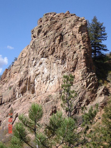
I spent about 15 minutes on the summit, then headed down. I was hoping to make it back to the trailhead in about an hour and a half. Before leaving the summit area, however, I took one picture looking basically straight down, over the cliff edge on the southeast side, to show just how steep this side of the summit block really is. A careful inspection of what I could see from the trail on the way down convinced that there might be one or more free-climbable lines up the east or southeast side, however, and I certainly intend to return one of these days to explore that possibility. It would be a real rush to gain this summit via a scramble up that impressive east face!

In less than an hour from the summit, I was back below St. Marys Falls, making good time. Then, however, the snow and ice on the shaded trail finally got the better of me, and I sustained what I have to chalk up as my first actual injury while climbing in the mountains. I slipped on a steep section of trail and managed to twist my right ankle in the gyrations needed to bring myself to a stop. I was forced to do an asymmetric limp back to the trailhead, taking much longer than planned. Indeed, as I write this, my elastic-wrapped ankle is still giving me occasional twinges, and it will be a few days before I can run again. Thus, my time down is sort of meaningless. Oh, well: I should have been more careful, and I certainly will in the future. And not to worry: it is healing.

Pictures from the trip can be seen at:

http://new.photos.yahoo.com/cftbq/album/5764607623307899681#page1

and

http://www.imagestation.com/album/pictures.html?id=2100339006


As always, long life and many peaks.

Monday, October 16, 2006


Molly does Kineo

Monday, 16 October: Well, I guess I have to face it. Fourteeners are over for this year. Snow has come to stay to the high country, and I’m not really equipped for full winter climb—except on a few of the easiest peaks, which I’ve already climbed. So now it’ll just be trying to stay in shape, pursuing whatever adventure I can on more accessible, lower, nearby peaks.

Since Monday was a beautiful fall day, but the weather forecast for Tuesday was much, much worse, I decided to run a day earlier than my usual schedule. And since there was ample time, I also decided that I should take Molly (my brother’s red German shepherd) up a local peak she hadn’t climbed before—even if I had. So, with the Honda back in operation (and gas in the tank), we drove up to the Gold Camp Road trailhead for a run up Kineo Mountain (38º47’25.8”N, 104º55’52.3”W, 9,478 ft.). IIRC, this would be at least climb number four for me.

After following the rugged Seven Bridges Trail up North Cheyenne Cañon almost to Jones Park, the route then leaves the trail on the west side of the mountain. From there, it’s several hundred vertical feet of bushwhacking up the ridge, on the north side of the crest. I don’t think I’ve ever followed exactly the same route twice. There are two or three rocky ridge points which can be either scaled or bypassed along the way, plus a little bit of scrambling through talus. Once the first major ridge point is gained, sections of half-decent climber’s trail can be followed to a point on the north side of the summit block.

As I’ve come to expect, Molly did just fine staying with me through the rocks, even in the one brief section where it gets a bit steep. We clambered up the last few feet to the summit one hour and one minute after leaving the trailhead, just about 2,000 feet below. We had only seen one other person along the way (and he had his dog with him, too).

The weather held clear and mostly windless. Even on the relatively exposed summit, I was comfortable in running shorts, without the gloves or earband I had brought, although I did wear long sleeves the whole way. I snapped a couple of pictures of Molly on the summit, bailed on trying a shutter-delay picture of myself for lack of a decent place to set the camera, and, after five minutes on the top, headed down.

Not far below the summit, there is a place where the trees open up, and I took advantage of it to get some pictures looking north, showing Pikes Peak (you can see the building on the summit), Mt. Garfield, Mt. Arthur, and Tenney Crags (all much closer!). Snow has fallen here, but I found nothing left of it up to 9,500 feet—actually, as I could see clearly, up to significantly higher altitudes. But “the Peak” carries a mantle of white which will, no doubt, last until spring.

The trip down was uneventful, although we did pass two or three parties of hikers on the trail. Still, there was mostly solitude. We got back to the parking lot in 47 minutes, close to my best time.

Pictures are posted at:

http://new.photos.yahoo.com/cftbq/album/576460762325246212#page1

Now, I’ll sign the SummitPost climbers’ log for Kineo yet again, and plan for other relatively low summits, while dreaming of higher peaks yet to come.

Saturday, October 07, 2006


Success at Inspiration Point

Saturday, 7 October: It was a sunny day in the city, but I know there’s still snow in the high country—to much snow, I’m afraid, to make climbing any of the nearby fourteeners feasible for the kids. Since we would need to take them with us to do a climb this weekend, it just didn’t seem feasible.
It also wasn’t feasible because tomorrow is my sister-in-law’s birthday, and we’re celebrating tonight, which makes being out on the road until (at least) late afternoon an impractical idea. So, of course, I went running and climbing “in my back yard.” I got out early in the day and went back to finish climbing Inspiration Point (38º, 47’, 40.5” N, 104º, 52’, 35.8” W, 7,154 ft.) in the clear sunshine. This time, I made it.
Once again, I took the most direct route there, up the ridge from the south. I’m now getting familiar with that route, and it only took about 43 minutes to get to the base of the rock. I was a little concerned by the moderate gusty winds blowing (it is October, after all), but I hoped that the unexposed nature of the chimney climb up the point would render this not much of a problem. I also made sure to take pictures looking both up and down from several points on the ascent.
The wind didn’t turn out to be much of a problem. The higher part of the ridge to the northwest shielded me somewhat, and what wind there was merely tended to blow me right against the north side of the rock where I was ascending. So I overcame the last of my trepidations, and successfully got past the two cruxes (cruces?) of the climb up. Once past the “wall” portion, there is a turn to the right (west) and only a gentle slope, punctuated with small and stable rocks, to the true summit.
There, the wind did hit me somewhat, and I elected only to sit, not stand, on the top, but it was really not hard to hold on. I took a few pictures, drank a little water, and headed down. I decided to time my downclimb. It’s only about 30 feet vertically, but it took just about four minutes. The two crux moves involve going over basically vertical lips, and finding footholds which are invisible from above. (I had taken great care, on the way up, to reverse my moves, as well as memorizing the locations of the invisible platforms!) They both went off without a hitch, but they are probably the two scariest moves I have done to date—including the downclimb of the western couloir on Crestone Needle.
Once down, the sunshine was just too good to squander, so, instead of going back by my ascent route, I continued west along the road, through the first tunnel, and found the spur of the Columbine Trail which took me back home down North Cheyenne Cañon. Even so, it only took me about 40 minutes to make the return trip.
A gallery of the pictures I took is at:

http://www.imagestation.com/album/pictures.html?id=2101026700

and a smaller set is at:

http://pg.photos.yahoo.com/ph/cftbq/album?.dir=/4adare2

Thursday, October 05, 2006


Jupiter and Venus set over Point 7,415, as seen from the south end of the Stratton Open Space park in early September, 2005.
Point 7,514

Thursday, 5 October: Thursday is one of my usual running days with Molly, my brother’s red German Shepherd. I was looking for something new, but still close to home.

So we started at the trailhead (well, one of them: there are several) for the Stratton Open Space in between his home and mine. I’ve taken Molly running there numerous times before, but the area is laced with many trails, so we’ve hardly ever taken the same route twice. Not long ago, we finally wound our way all the way up the slopes (it’s right on the edge of the foothills, sloping consistently up from east to west) to the one trailhead at the top, located right on Gold Camp Road as it traverses the eastern face of the mountains above the reservoirs.

This time, I looked up at the hills across and above the road. The trail comes out right below a prominent “bump” which punctuates the skyline as seen from below. It appears in many of the evening sky photos which I have taken from various places within the SOP park area. So I decided, more-or-less on the spur of the moment, to see whether or not a feasible path could be found to climb this point, which stands a few hundred feet above the road. We reached the road in just 28 minutes from the trailhead, having come 1.72 miles, and, as the weather was mild and clear with no clouds appearing to roll in, it seemed like a good plan to pursue.

Upon crossing the road (which carries very little traffic most of the time), I was a little surprised to find an obvious, but little-used, trail leading into the drainage to the left (south) of the rock outcropping. I happily plunged ahead, and let Molly back off her leash after getting a few yards into the brush and away from the road.

Moving west up the drainage, I found roughly what I expected: varied terrain mixing loose scree, vegetation-covered slopes, and partially open areas carpeted with leaf/needle litter. However, I also found bits of trail, clearly showing that others had been this way. I followed these where I could, always looking up to my right for the best place to leave the bottom of the drainage (where I mostly found myself), and strike out in earnest for the top of the rock outcropping. The point for which I was aiming is on a spur extending to the east from the main ridge, which runs basically north to south, so I knew I probably didn’t want to follow the drainage bottom all the way west, to where it finally topped out. This would make the gentlest path to my goal, but not by any means the shortest. With no really difficult climbing to be seen, it made sense to turn right, and more steeply up, at some point.

When I finally did this, I only had to climb about 50 feet of fairly steep scree slopes to gain the ridge top. I came out at a point in between the highest point on the spur and the rocks visible from below (no surprise). The GPS gave me a reading of 7,478 ft. here. A few minutes later, when I bypassed some rocks with a small tree growing right out of them on the ridge crest, and got to the actual high point, I recorded an elevation of 7,514 ft. First, though, I went down to the east to a prominent outcropping from which I hoped the road would be visible. It wasn’t, at least not directly below me, although I could see the point not far away to the south where the road finally makes its big turn through a cut in the rock, and crosses around to the west side of the ridge, and into North Cheyenne Cañon proper. So I knew I was close to the point visible from below, but still a bit back from it, and above it. Good enough.

Molly had hung in with me all the way. She has already proved herself to be very good on both rocks and scree, and I had no doubts, once we started up the drainage west of the road, that she would be able to make this little excursion with me. When we topped out, I was sorry that I hadn’t thought to bring my camera. I found quite a lot of level space on the ridge crest, punctuated by small groups of rocks. The area would make a good place from which to observe fourth of July fireworks (in defiance of the wishes of the city government, which arrogantly blocks access to this section of Gold Camp Road every year on the fourth, precisely because it would be a good place from which to observe said fireworks). However, I have no doubt that I’ll be back, and with Molly, so I’ll have another opportunity to get some nice photos of this spot. It’s another one of those little gems, right on the edge of the city, which many have seen from afar, but which few have visited. Now I have.

It had taken just about 15 minutes to climb to the top from the road, about 470 feet vertical. After spending five minutes on top, Molly and I got back down to the road in about ten minutes. We saw a couple of hikers and bicyclists below the road on the way up and on the way down, but absolutely no one on our little climb—how great! It only took 22 minutes to get all the way back down to the trailhead. Another interesting, and original, run/climb, on a beautiful and sunny fall day. Now, if I could just get the weather to hold, and the scheduling to work out, so as to pack in one more fourteener before this balmy weather goes away, I’ll be really happy.

Sunday, October 01, 2006

The summit of Kineo Mtn.,
early on a May morning.
Inspiration Point

I had to do something having to do with climbing today. Yesterday was the perfect Saturday I had been waiting for for two months. There was not a cloud in the sky all day. There was no significant wind. There was not a hint of precipitation. Days of sunshine had melted a good deal of the snow in the high country. All of Colorado was calm and warm.
But did I get to climb anything? No, of course not! That was the day—the day—that had to be dedicated to helping my friend Lorraine get ready to move back to Washington (state). It's not that I minded helping at all. She's a sweet person and needed our (the family's) help, and, well, this was the day. So I looked at the wide-open, blue sky from the plains east of town all day while I packed and moved box after box after box of stuff.
Thus, with the warm weather (but not the unbroken sunniness) continuing for another day, I needed to get out and stretch my legs. Instead of just running up the cañon, I inched a little closer to climbing to the top of Inspiration Point.
Inspiration Point is an intriguing finger of rock which sits above the north side of North Cheyenne Cañon, at the point where Gold Camp Road turns to the west and enters the cañon. The road is cut into the ridge just beside it, exaggerating its prominence. The topo map shows an elevation somewhere between 7,000 and 7,200 ft. (I estimate it as 7,150.)
I took the shortest, though not really the easiest, route to get there: up the Columbine Trail a short way (perhaps a third of a mile), then across the road and onto an old, largely unused, trail which turns directly up the ridge which runs north up to the point. The trail gets sketchier as one climbs, and in places all but disappears. Vegetation, including small cacti, is trying to reclaim it in places.
This is not the easiest route because in places scrambling over the rocks on the ridge crest is required, and, although it only comes in short sections, some of this climbing has to be rated at least Class 3. Worse, some of it is loose, so care is required. The easy way is to follow the trail a mile or so farther up the cañon, then take the little-known spur trail which leads up the Columbine Falls drainage to intersect the Road at Tunnel #1, and then follow the road back to the east to reach the point. Easier, but considerably longer; pick your poison. This time, I picked short, although I've also done it the other way, and, no doubt, will again.
Anyway, just under 40 minutes brought me to the road and the base of the rock. The easiest way, as I see it, to get to the top, is to wedge oneself up a narrow chimney on the north (road) side, to reach a small level space under the final slope to the top. It's very steep—basically a wall, but with abundant ledges and handholds. On a previous attempt, last month, I had gotten ten feet or so above the last level ground, where I called it quits because the rock was still a tad wet from recent rains.
I had, and have, no qualms about doing a new climb in several progressive attempts like this. I did the east face of Mt. Cutler the same way last year, and on the finger I've dubbed "Columbine Spire" farther up the cañon: several partial climbs before I felt comfortable with the whole ascent. Inspiration Point is a much shorter technical climb than Mt. Cutler, but much, much steeper. So, as before, I went slowly, and did a lot of backtracking, making sure that I could downclimb each mini-pitch before going on to the next one. Here, that was even more important, as it was clear from the start that I would have no choice but to descend my ascent route. On Cutler, I still have not downclimbed the east face, choosing to run down the easy trail on the west side instead. On Inspiration Point, no such option exists: The other side, the south side, is longer (since it's on the down-ridge side), smoother, and bowed outward. I don't think I could negotiate it in either direction.
So, as I said, I inched closer this time. I got myself to within one or two moves of the little level place I mentioned earlier. Going over the lip to reach that pause in the climb is going to involve probably the greatest exposure of the whole climb, if I've got it scoped out right. After that, the slope relents somewhat, and the climber turns to the right (west) to scramble up some highly textured rock to the very small summit. It's steep there, but not a wall.
Still, I decided that getting to where I could see that last, committing move was enough for this time. I can do it, and maybe the next time will be when I actually stand (or maybe just sit...) on the actual summit. I doubt that very many people have actually done so.
I returned, not the way I had come, but by following the road north a short distance to where a trail leads down through the Stratton Open Space park, and then south on streets to home. Before that, however, I did climb a less challenging point just to the east, which I decided to call "Little Inspiration." It's within a few feet of the same elevation as Inspiration Point, and I took a few pictures there, which I will stitch together into a panorama. This includes a good view of the point inself, although, unfortunately, my intended climb route is mostly hidden from view. At some point, I'll either figure out how to include pictures with this blog, or I'll post the panorama somewhere else and provide a link. Overall, about 3.8 miles, and roughly 1,000 feet of climb.